
I’ve lost count of how many times a client called me frustrated because their cameras caught an intruder on one angle but completely lost them on the next.
Yes, a well-designed app can link multiple PTZ cameras to display a single target’s movement track on a map. This requires AI-powered multi-camera tracking, geo-referenced camera positions, and a unified software platform that stitches detection events from each PTZ into one continuous path overlay.
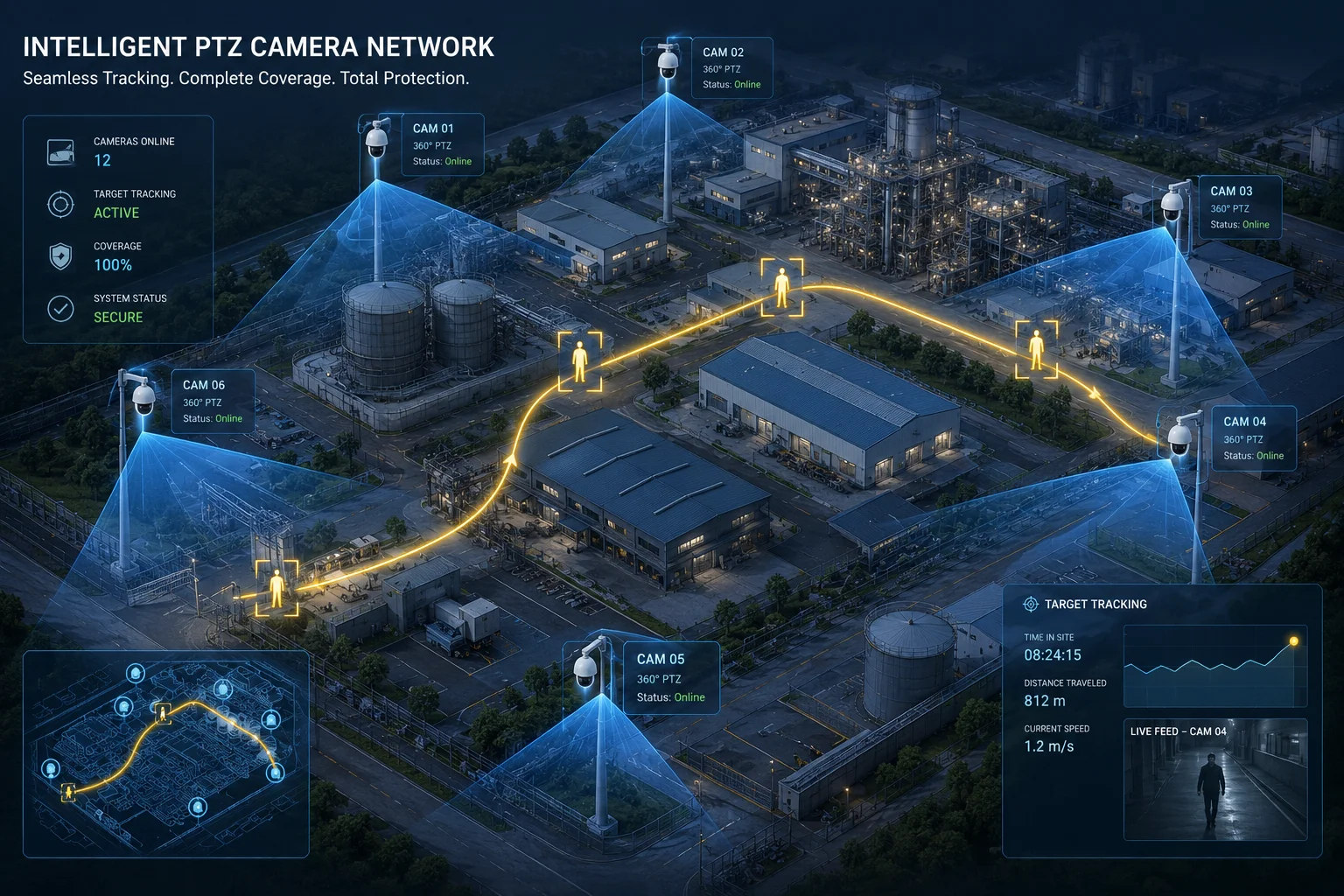
Tracking a person or vehicle across a large site with just one camera is nearly impossible. PTZ cameras1 cover wide areas, but they have blind spots during pan and zoom. The real power comes when multiple PTZs work together as a system. Below, I break down exactly how this works, what each piece of the puzzle does, and what you need to make it happen on your project.
Table of Contents
How Does the “Multi-Camera Tracking” Feature Hand Off a Target From One PTZ to Another?
I remember a project manager in Texas telling me his biggest fear was not the break-in itself, but the moment the intruder walked out of one camera’s view and simply vanished.
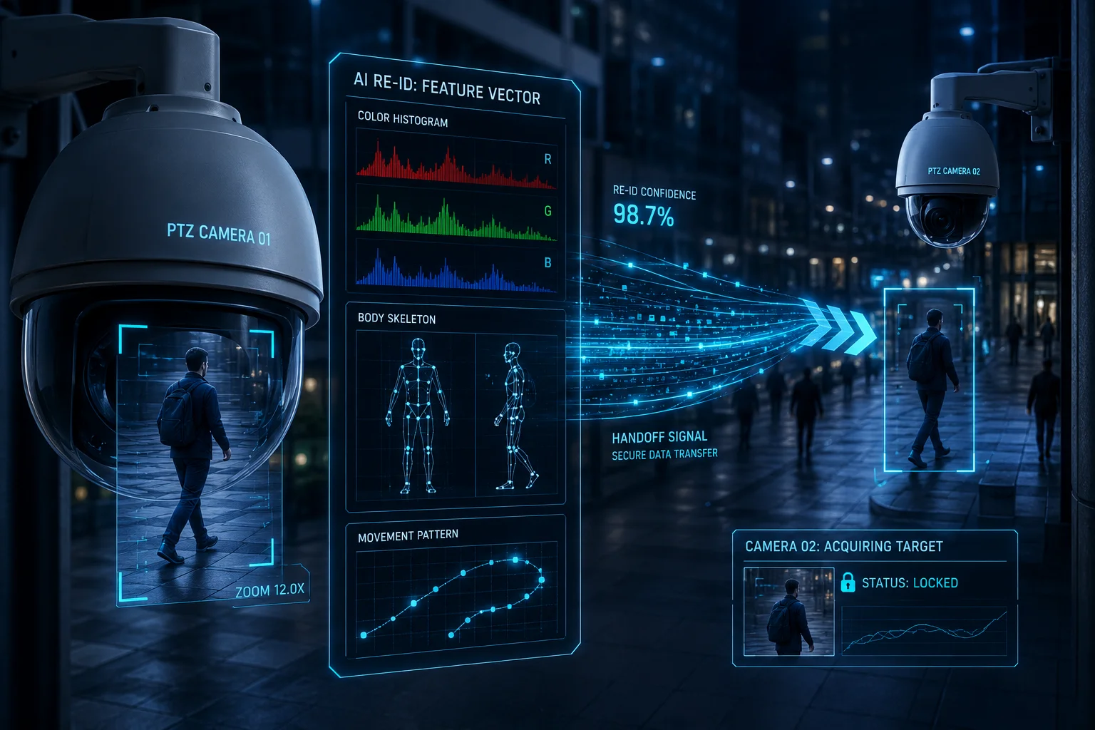
Multi-camera tracking hands off a target by using AI re-identification (Re-ID) algorithms. When a PTZ loses a target at the edge of its field of view, the system alerts the next camera in the coverage chain to pick up a subject matching the same visual signature, such as clothing color, body shape, and movement direction.
How the Handoff Actually Works Step by Step
The handoff process is not magic. It follows a clear logic chain that your system runs in milliseconds.
First, Camera A detects a target using AI human or vehicle detection. The system creates a “feature vector2” for that target. Think of it as a digital fingerprint based on appearance. This includes color histogram, body proportions, and walking speed.
Second, when the target reaches the edge of Camera A’s field of view, the system checks which cameras have overlapping or adjacent coverage zones. This is where your camera map layout matters. Each PTZ must have its GPS coordinates3 or pixel-mapped position registered in the software.
Third, the system sends a “pre-alert” to Camera B. Camera B begins scanning its coverage area for any object matching the feature vector. Once it finds a match above the confidence threshold4 (usually 85% or higher), it locks on and begins PTZ auto-tracking.
Key Technical Requirements
| Component | Role | Why It Matters |
|---|---|---|
| AI Re-ID Engine | Matches target appearance across cameras | Without it, each camera treats every person as a new detection |
| Camera Map Registration | Defines spatial relationships between PTZs | The system needs to know which camera is “next” in the path |
| Low-Latency Network | Ensures handoff commands arrive in time | A 2-second delay means the target walks 3 meters untracked |
| Overlapping FOV Zones | Provides a transition area for matching | Zero overlap means zero chance of a clean handoff |
What Happens When Handoff Fails?
In real-world conditions, handoff can fail. Rain, fog, or a target changing clothes can break the Re-ID match. Good systems handle this by keeping a “last known position” marker on the map and expanding the search radius on nearby cameras. Our dual-lens linkage cameras help here. The fixed wide-angle lens maintains a constant overview while the PTZ lens zooms in. Even if the PTZ loses tracking, the wide lens still records the general area. This gives the system a second chance to re-acquire the target.
For sites using our 4G solar PTZ systems in off-grid locations, bandwidth matters. The Re-ID data packet is small, usually under 5KB per handoff event. So even on a 4G connection with limited upload speed, the handoff command travels fast. The heavy video stream stays local on the SD card or NVR. Only metadata and alert snapshots go over 4G.
Can I See a “Breadcrumb” Trail of an Intruder’s Path Across My Entire Property?
One of my clients in Canada runs a 200-acre solar farm. He told me that catching the thief on camera was useless if he could not show the police exactly where they walked and which panels they touched.
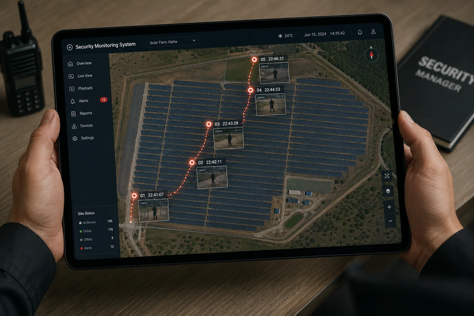
Yes, you can see a breadcrumb trail. The app plots each detection event as a timestamped dot on your site map. When connected in sequence, these dots form a visual path showing exactly where the intruder moved, when they moved, and which cameras captured each segment.
How the Breadcrumb Trail Gets Built
Each time a camera detects the tracked target, it logs three things: GPS-mapped position, timestamp, and a snapshot. The app collects these logs and draws them on your site map as a series of connected points.
This is not a live GPS tracker on the intruder. It is a reconstruction based on camera detection events. The accuracy depends on how many cameras you have and how well they cover the site. More cameras mean more dots. More dots mean a smoother trail.
What Data Each Breadcrumb Contains
Every point on the trail is clickable. When you tap a breadcrumb dot in the app, you see:
- The camera name that captured it
- The exact time of detection
- A snapshot or short video clip
- The confidence score of the AI match
This is powerful evidence for law enforcement. Instead of handing police 12 hours of raw footage from 8 cameras, you hand them a clean map with a timeline. They can see the intruder entered from the north fence at 02:14 AM, walked past Building C at 02:17 AM, and exited through the east gate at 02:23 AM.
Practical Setup for Breadcrumb Tracking
| Setup Step | What You Do | Tool Used |
|---|---|---|
| 1. Upload Site Map | Import a satellite image or CAD drawing of your property | App or VMS software |
| 2. Place Camera Icons | Drag each camera to its real-world position on the map | App map editor |
| 3. Define Coverage Cones | Draw the field of view angle for each PTZ | App map editor |
| 4. Enable AI Tracking | Turn on human/vehicle detection for all cameras | Camera web interface |
| 5. Link Cameras to Group | Assign all PTZs to one “tracking group” | VMS or app settings |
Limitations You Should Know
The breadcrumb trail has gaps if your camera coverage has gaps. If there is a 50-meter stretch between two cameras with no overlap, the trail will show a jump. The app draws a dashed line between the two points to indicate “assumed path” versus “confirmed path.” For critical areas like entry points and high-value zones, I always recommend overlapping coverage. For low-risk corridors, a gap is acceptable as long as entry and exit points are covered.
Our 38X and 40X optical zoom PTZs help fill gaps without adding more cameras. A single PTZ with 40X zoom can cover a 200-meter corridor and still capture face-level detail at the far end. This means fewer cameras, fewer breadcrumb gaps, and lower hardware cost for your project.
Will the App Automatically Switch to the Nearest Camera’s Live View as the Target Moves?
I had a distributor in the Middle East ask me this exact question. He said his operators were wasting time manually clicking between camera feeds during an active intrusion.
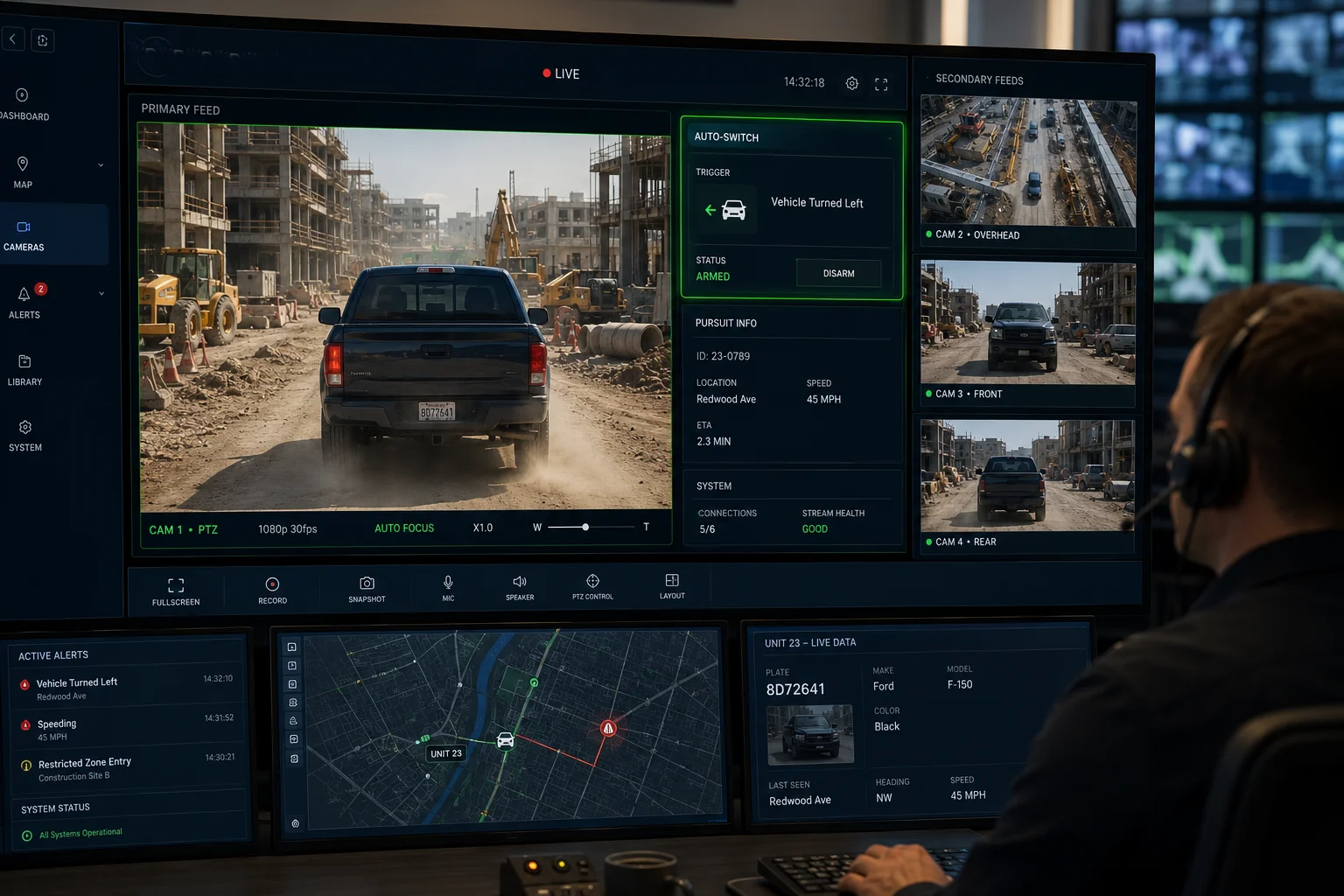
Yes, the app can auto-switch the live view to the nearest camera as the target moves. This feature, often called “auto-follow” or “live pursuit mode,” keeps the operator’s screen locked on the target without any manual input. The system uses the tracking handoff data to determine which camera has the best current view.
How Auto-Switch Works in Practice
When you activate live pursuit mode in the app, the system does three things simultaneously:
First, it keeps the current camera’s PTZ locked on the target using AI auto-tracking. The camera physically pans and tilts to follow the person or vehicle.
Second, it monitors the target’s position relative to the coverage boundaries. When the target approaches the edge, the system pre-loads the next camera’s stream in the background.
Third, when the handoff triggers, the app switches your main display to the new camera’s feed. The transition takes about 0.5 to 1.5 seconds depending on your network speed. On a local LAN with an NVR5, it is nearly instant. On a 4G connection, expect a brief buffer.
Operator Experience vs. Fully Automated Mode
There are two ways to use this feature:
Semi-automatic mode: The app shows a pop-up notification saying “Target moving to Camera 3. Switch view?” The operator clicks yes or no. This is good for sites with many false positives where you want human confirmation.
Fully automatic mode: The app switches without asking. The operator just watches. This is better for high-security sites where response time matters more than false alarm filtering. A trained operator can always override and manually select a different camera if the auto-switch picks the wrong one.
Network Requirements for Smooth Auto-Switch
This feature is bandwidth-hungry because you are streaming live video from multiple cameras simultaneously (the current view plus pre-buffering the next). Here is what I recommend:
For LAN-connected NVR setups, this works out of the box. Gigabit Ethernet handles multiple 4K streams without issue.
For 4G solar sites, you need to make trade-offs. I suggest setting the live pursuit stream to sub-stream quality (720P or even D1 resolution) during auto-switch. Once the operator confirms which camera to focus on, they can manually bump it to main stream (4K). This keeps 4G data usage under control while still giving real-time situational awareness.
Our cameras support dual-stream output specifically for this reason. The main stream records locally in full 4K. The sub-stream goes over 4G for remote viewing. You get the best of both worlds: full evidence quality on the SD card and responsive remote monitoring over cellular.
Does This Feature Require a Central Server, or Is It Managed via P2P Camera-to-Camera Sync?
A system integrator in Europe once asked me if he needed to sell his client a $10,000 server just to enable multi-camera tracking. It is a fair question because the answer changes the entire project budget.
Multi-camera tracking typically requires a central processing point, but it does not always mean a dedicated server. Some systems use an NVR with built-in AI as the central brain. Others use cloud-based processing. True P2P camera-to-camera sync for tracking is rare in current products because the AI computation load is too heavy for edge devices alone.
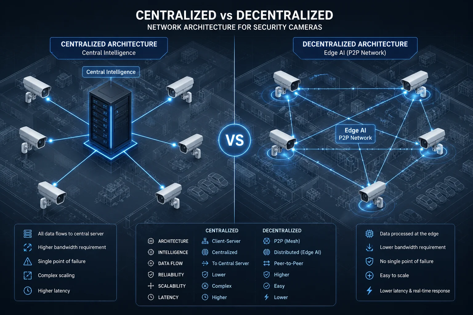
Understanding the Three Architecture Options
There is no single answer here. The right choice depends on your site size, budget, and network conditions. Let me break down each option.
Option 1: Central Server (NVR or Dedicated PC)
This is the most common setup for professional installations. An NVR or a PC running VMS software (like Milestone or Blue Iris) receives all camera streams. The server runs the AI Re-ID engine, manages handoffs, and generates the breadcrumb trail.
Pros: Most reliable, lowest latency for handoffs, supports the most cameras. Cons: Higher upfront cost, single point of failure if the server dies, requires on-site hardware.
Option 2: Cloud-Based Processing
The cameras send detection metadata (not full video) to a cloud server. The cloud runs the Re-ID matching and sends handoff commands back to the cameras. The breadcrumb trail lives in the cloud app.
Pros: No on-site server needed, works well for multi-site management, automatic software updates. Cons: Depends on internet connectivity, ongoing subscription cost, slight latency increase for handoffs.
Option 3: Edge AI with P2P Coordination
This is the newest approach and still maturing. Each camera has its own AI chip powerful enough to run basic Re-ID. Cameras communicate directly with each other over the local network to coordinate handoffs.
Pros: No server needed, works in fully off-grid setups, no single point of failure. Cons: Limited to small camera groups (4-8 units), Re-ID accuracy is lower than server-based, firmware complexity increases.
Which Architecture Fits Which Project?
| Project Type | Best Architecture | Reason |
|---|---|---|
| Large commercial site (20+ cameras) | Central Server (NVR/VMS) | Needs processing power for many simultaneous tracks |
| Multi-site retail chain | Cloud-Based | Central management across locations without local IT staff |
| Remote construction site (4G solar) | Edge AI with P2P | No reliable internet for cloud, no power for a server |
| Government or critical infrastructure | Central Server + Redundancy | Requires highest accuracy and cannot tolerate cloud dependency |
What We Offer at
Our dual-lens AI tracking cameras have edge AI6 chips that support basic P2P handoff between 2-4 cameras without any server. For larger deployments, our cameras are fully ONVIF7 and RTSP8 compatible, so they integrate with any major VMS platform that supports multi-camera tracking.
For our 4G solar clients in remote areas, I usually recommend a hybrid approach. Use edge AI for real-time tracking on-site, and sync the breadcrumb trail data to the cloud app when bandwidth allows. This way, the tracking works even if 4G drops out temporarily. The map and trail data uploads once connectivity returns.
The key point is this: you do not need to choose one architecture forever. Start with edge AI for a small deployment. If the site grows, add an NVR as the central brain. Our cameras work in both modes without firmware changes. That flexibility protects your client’s investment as their security needs scale up.
True P2P camera-to-camera sync9 for tracking is rare in current products because the AI computation load is too heavy for edge devices alone.
Conclusion
Linking multiple PTZs to track a single target across a map is achievable today with the right combination of AI Re-ID, proper camera placement, and a suitable processing architecture. Whether you choose server-based, cloud, or edge P2P depends on your site conditions and budget.
1. Overview of PTZ camera capabilities and typical use cases in security. ↩︎ 2. Defines feature vectors as mathematical representations of object attributes in machine learning. ↩︎ 3. Explains how GPS coordinates are used to pinpoint camera locations on a map. ↩︎ 4. Machine learning term defining the minimum probability for a positive match in re‑identification. ↩︎ 5. Network Video Recorder – central storage and processing device for IP cameras. ↩︎ 6. Explains edge AI processing on devices like cameras, enabling local tracking without servers. ↩︎ 7. ONVIF standard for camera interoperability; relevant for integrating multiple PTZ cameras. ↩︎ 8. RTSP protocol for streaming video from IP cameras; important for live view and handoff. ↩︎ 9. Peer‑to‑peer communication concept applied to camera coordination for tracking handoffs. ↩︎